ISLE OF PINES (ILE DES PINS) - NEW CALEDONIA
(KUTO REGION)
LAST VISITED JAN 2019
 The ISLE OF PINES is part of NEW CALEDONIA - abt 50km from the south-east tip of GRAND TERRE (the main island) and 100km in a straight line SE of the capital NOUMEA. Distance/direction from MARE - 110km/SSW
 ISLE OF PINES-NEW CALEDONIA (5) relative to other places in this section - 1 KIBOLA-KIRIWANA-PNG 2 MYSTERY ISLE-VANUATU 3 YEJELE-MARE 4 NOUMEA-NEW CALEDONIA 5 ISL OF PINES-NEW CALEDONIA 6 LIFOU-NEW CALEDONIA.
Numbers may be clearer if you click-expand image.
 The Isle of Pines is abt 2/3 the size of Mare.
LADY T and I first visited in the 70s, flying in from Noumea for a 4 day stay. It is a real nice island, - but unfortunately the cruise ship anchorage is nowhere near as protected as at Mare, Noumea, Port Vila or Mystery island, which lessens the chance of successfully landing - I have managed 4 in 6 on our cruise visits. Better than a lady on the tender our first visit - this was her first success in 4. Maybe I'm exaggerating the problem - LADY T is running 5 in 7 and my son 1 in 1.
Note that cruise line HOLLAND AMERICA calls the visit "KUTO" after the arrivals bay, not "ISLE OF PINES" as do the other cruise lines
 The trouble with this part of the ISLE OF PINES is that the headlands are relatively low/short and offer poor shelter from the prevailing south-east trade winds which blow more often than not. Plus the water close to shore in more sheltered areas is a bit shallow for bigger ships. So on blustery days the liner tends to rock and roll a bit which makes "debarking" (their term not mine) a bit difficult. Not for want of trying - on our November 2015 call-in, the captain of CARNIVAL SPIRIT manoeuvered for at least 40 minutes to different parts of the bay trying to find calm-enough water to make tender loading safe for the old and infirm. November 2014 on CARNIVAL LEGEND was much the same. This must be heartbreaking to the locals who would have already set up their tents and stalls in the landing area - plus of course all passengers who have booked sightseeing, snorkeling and diving trips - there is the usual diverse range of paid SHORE EXCURSIONS offered by the ships/locals - take care in pre-booking those offered by locals: not sure abt refunds if you don't get off the ship.
Gotta say recent visits much more successful - I'm running 3 in 3.
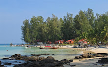
 This is the region where the tenders land - a nice spit area in the island's south-west, coincidentally where our resort back in the 70s was located. The spit has frontages to both bays as did the hotel - a riot by indigenous people during the independence push of the 80s burned it down.
When ships are due, locals set up their tents and stalls along that clearing where the spit is narrowest. Both the beaches and that small island vicinity (right of lower-center) are popular with people off the ship.
 One of the locals' trip stalls. These offer excursions at significant discounts to the ships' stuff, but make sure you will return well before sailing time.
This area offers all the usual stuff - beers (better than ships' prices) and other drinks, food, touristy clothing-trinkets, the ubiquitous hair braiding/massage/yada. There are some toilets in the area.
PLAGE DE KUTO
 KUTO BCH can be seen from the ship - above is the view when you hit it near the landing pier. This is a very sheltered strip of sand from the prevailing south-easterlies - it may be a bit blustery and choppy out in the bay where the ship is but including my fly-in I must have visited the beach on 10 different days: in each the wind was a mere zephyr and the water glassy - no coincidence KUTO BAY is a favoured mooring spot for cruising yachts and the island's small boats.
The beach is about 1 km long but only the first 300m attract people on liner days so if you are seeking seclusion there is plenty of sand for you.
 RESTAURANT KU BUGNEY is about 300m down the beach from the pier end - cool terrace to sit and eat/drink but prices a bit eye-watering for this cheap-skate ($AUD12 for a beer). Associated small boutique hotel is inland behind the trees.
 PLAGE DE KUTO looking back from KU BUGNEY towards the pier - gorgeous white sand, plenty of vegetation in back of beach for shade. High tide mark in OOCT 2017showed plenty of width left at full tide. Water calm and clear, bottom shelves gently, I've never experienced currents. Area not all that great for snorkeling with a sandy bottom and no coral (there probably is some up closer the pier area) but PLAGE DE KUNUMERA'S ROCHER DE KAA NEUMERA (see downpage) is only about 5 minutes' walk directly to the left across the isthmus.
PLAGE DE KAA NUE MERA
 PLAGE DE KAA NUEMERA MAIN (EAST) [KUNUMERA on map) is directly across the spit from PLAGE DE KUTO. The pale blue track between the 2 most popular areas takes a bit over 5minutes. From the tender pier walk thru the locals' stalls area and take the track (white on map) veering to the right. 3 minutes will get you to the popular area around that landlocked island (ROCHER DE KAA NUEMERA - Rock Of Kaa - Nuemera).
Note KAA NUE MERA (KANUMERA) SUD (my name - SUD = south, I think, from my French lessons 59 years ago. I failed French BTW) - bit hard to access from THE ROCK because the first 150m is a hard to walk rocky shoreline: best way is to take the track immediately where the road from the tender pier hits the mid-spit road, not many do. SUD is nice enough, gets few visitors - a good place for people seeking seclusion, but so is central/eastern MAIN.
I didn't put a linear scale on the image - straight line distance between the place markers for TENDER PIER (left) and KAA NEU MERA MAIN (right) is 750M.
 The most popular location along here is not on the beach but in the shade of the woods behind ROCHER DE KAA NUE MERA. Besides the shade, this spot is close to good snorkelling around the rock and good swimming/paddling. Local dudes have a few tables under the trees to rent out snorkelling gear, kayaks and glass bottomed boat rides.
 Entrance to the water here is easy for both snorkellers and splashers.
 This is a 2014 pic which shows a higher tide at the spit, but access to water still fine.
 The ROCK is a very popular snorkelling area. I took my face mask out and swam around the islet - 350m. There are patches of fringing coral and a fair few fish which will keep novices happy but perhaps advanced fin-flappers will be less than whelmed. I found the best coral approximately where those heads in background are but on the OTHER SIDE (EASTERN) of the islet. Just seaward of this was a big patch of very dead coral. Out in front of THE ROCK(the most seaward part) was not much of interest. There are some okay patches of coral in the bay off KAA NEU MERA MAIN.
ROCHER DE KAA NUE MERA
 ARROW shows best snorkelling spot. Note coral patches closer camera left.
 600M long PLAGE DE KAA NUE MERA MAIN in OCT 2017 was pretty drop dead gorgeous - here is the classic tropical beach of blinding white sand backed by casuarinas, coconut palms and Cook Island Pines. Moderate profile with lotsa sand mid-tide in this shot: high tide mark showed plenty of room left to lay a towel/saraong. Off the sand the water shelves gently and there are some ok coral patches a bit further out to snorkel.
Despite facing into the prevailing south east trade winds, the above shot shows no problems. For a start any time your tender makes it to shore, those winds are not too strong. Secondly KAA NUE MERA BAY has a pretty narrow entrance thus blocking a lot of swell. Third(ly?) there is a pretty good BARRIER REEF about 7km offshore which blocks a fair bit of the bigger ocean waves.
ARROWS - OFF WHITE points to ROCHER ISLET while YELLOW to the very southern end of KAA NEAU MERA SUD.
 2014 higher tide saw a much narrower beach in background. This may have been a KING tide (proper name SPRING tide: nothing to do with the season) associated with FULL MOON or NEW MOON (when the moon and sun are aligned and working in tandem to pull the tide up) or maybe the result of prior STORM EROSION of the beach.
 The far eastern end of KAA NEU MERA MAIN featured the boutique OUE TERRA BEACH RESORT which decided to block off the last 150m of sand. Dunno how legal this is - in AUSTRALIA or HAWAII no way could it happen. No matter - most cruise visitors confine themselves to the first 100m of the beach - central and eastern sections are pretty deserted. I wasn't fussed - I reckon their beers in that rather spiffy peaked-roof beachside bar-restaurant would have been way above my pension grade.
PLAGE DE KAA NUE MERA 180 degrees from previous shot.
 Gorgeous.
---------------------------------------------------------------------
ACCESSING THE ISLE OF PINES - unlike other beaches/islands in this section, the ISLE OF PINES gets many non cruise-liner visitors. There's a bunch of small boutique-like resorts around the island and regular AIR CALEDONIE commercial flights from NOUMEA - plus BETICO run a fast ferry 3 days a week.
DAYTRIPS apparently can be arranged by several NOUMEA operators - GOOGLE will find them.
The island is also a popular call in for cruising yachts.
-------------------------------------------------------------------
(KUTO REGION)
LAST VISITED JAN 2019


Numbers may be clearer if you click-expand image.

LADY T and I first visited in the 70s, flying in from Noumea for a 4 day stay. It is a real nice island, - but unfortunately the cruise ship anchorage is nowhere near as protected as at Mare, Noumea, Port Vila or Mystery island, which lessens the chance of successfully landing - I have managed 4 in 6 on our cruise visits. Better than a lady on the tender our first visit - this was her first success in 4. Maybe I'm exaggerating the problem - LADY T is running 5 in 7 and my son 1 in 1.
Note that cruise line HOLLAND AMERICA calls the visit "KUTO" after the arrivals bay, not "ISLE OF PINES" as do the other cruise lines

Gotta say recent visits much more successful - I'm running 3 in 3.

When ships are due, locals set up their tents and stalls along that clearing where the spit is narrowest. Both the beaches and that small island vicinity (right of lower-center) are popular with people off the ship.

This area offers all the usual stuff - beers (better than ships' prices) and other drinks, food, touristy clothing-trinkets, the ubiquitous hair braiding/massage/yada. There are some toilets in the area.
PLAGE DE KUTO

The beach is about 1 km long but only the first 300m attract people on liner days so if you are seeking seclusion there is plenty of sand for you.


PLAGE DE KAA NUE MERA

Note KAA NUE MERA (KANUMERA) SUD (my name - SUD = south, I think, from my French lessons 59 years ago. I failed French BTW) - bit hard to access from THE ROCK because the first 150m is a hard to walk rocky shoreline: best way is to take the track immediately where the road from the tender pier hits the mid-spit road, not many do. SUD is nice enough, gets few visitors - a good place for people seeking seclusion, but so is central/eastern MAIN.
I didn't put a linear scale on the image - straight line distance between the place markers for TENDER PIER (left) and KAA NEU MERA MAIN (right) is 750M.


ROCHER DE KAA NUE MERA


Despite facing into the prevailing south east trade winds, the above shot shows no problems. For a start any time your tender makes it to shore, those winds are not too strong. Secondly KAA NUE MERA BAY has a pretty narrow entrance thus blocking a lot of swell. Third(ly?) there is a pretty good BARRIER REEF about 7km offshore which blocks a fair bit of the bigger ocean waves.
ARROWS - OFF WHITE points to ROCHER ISLET while YELLOW to the very southern end of KAA NEAU MERA SUD.


PLAGE DE KAA NUE MERA 180 degrees from previous shot.

---------------------------------------------------------------------
ACCESSING THE ISLE OF PINES - unlike other beaches/islands in this section, the ISLE OF PINES gets many non cruise-liner visitors. There's a bunch of small boutique-like resorts around the island and regular AIR CALEDONIE commercial flights from NOUMEA - plus BETICO run a fast ferry 3 days a week.
DAYTRIPS apparently can be arranged by several NOUMEA operators - GOOGLE will find them.
The island is also a popular call in for cruising yachts.
IF YOU SEE MISTAKES OR HAVE ADDITIONAL INFORMATION, PLEASE POST BELOW.
BUT IF YOU HAVE QUESTIONS PLEASE ASK THEM IN THE FORUM SECTION WHICH I CHECK MOST DAYS WHEN NOT TRAVELLING - WHEREAS I SELDOM REVISIT THESE INDIVIDUAL DESTINATION PAGES.
-------------------------------------------------------------------


1 comment:
replica wallets z56 d3x70k0i76 replica designer bags wholesale d89 e2n93a8p78 high end replica bags p82 d5w28m4q48
Post a Comment