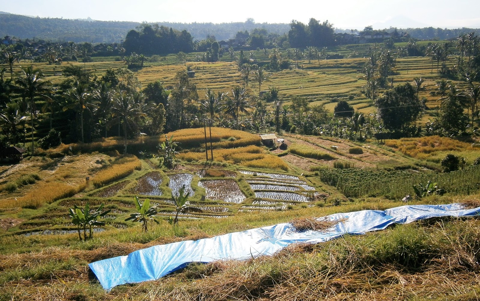
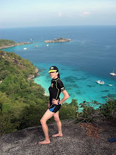
DUNK ISLAND is a compact island abt 4km off the mainland coast opposite WONGALING BEACH/SOUTH MISSION which are a part of the MISSION BEACH area in tropical north Queensland.

You are looking only a few degrees west of due north in this image.

DUNK is 125 km in a direct line from Cairns, 160 from Townsville and 1330 from Brisbane. By road WONGALING is - 160/230/1370km respectively.
Dunk is not part of the GREAT BARRIER REEF which can be seen further offshore. It is a continental island - a former higher area isolated by sea level increase.
THE BEACHES

DUNK has some nice beaches, most in the north-WEST of the island close to the resort, campground and airstrip. The east coast at left is largely beachless as is much of the southern peninsula on both sides.The section between PALLON and COCONUT beaches is largely mangroves.
You are looking south-south-east in this image so that those nice north-west beaches are at the BOTTOM RIGHT of the image.
BEST BEACH?
I dunno what is the best beach: I reckon this would vary depending on personal wishes:
BEST LOOKING
BRAMMO BEACH.

BRAMM0 is the resort beach, stretching 800m from the the foot of the hinglands to the pier. Past the pier it becomes the northern shore of THE SPIT.
 BRAMMO from in front of the camp area looking towards MT. KOOTALOO. The resort is out of frame right.
 Looking west - note some rock and stone exposed in area close to camera low tide - ditto down in front of the camping area just this side of the pier. Better mid beach.
THE SPIT
- is arguably just as attractive as BRAMMO.
 THE SPIT from the MT KOOTALOO viewpoint.
 Northern side of the spit a continuation of BRAMMO BEACH - southern side of PALLON BEACH. When prevailing south-easterly trade winds get blustery the lack of protective landscape or vegetation means it can get a bit blustery on the sand (this can actually be a blessing on hot days) although the water on the northern side tends to be smooth. Not so the southern side, where the south-easterlies can chop up water.
During my visit some kite surfers took advantage of this exposure - made THE SPIT their base.
 End of THE SPIT a great place to check sundown over the mainland.
MOST POPULAR
No doubt BRAMMO is most popular when the resort is open, but if daytrippers are the only visitors it seems MUGGY MUGGY attracts more. Maybe because it's accessed is by a short and pleasant rainforest track from the east end of Brammo - and that water-taxi handouts mention
good snorkeling (um too shallow and coral bleached when I visited).
 MUGGY MUGGY must get the award for MOST TROPICAL too. Those palms in back of beach don't hurt - provided some nice shade.
Plenty of big pebbles in the foreground but there is no shortage of finer sand on MUGGY MUGGY.
Pic a bit dull, shot on an overcast day threatening to rain.
MOST ISOLATED (of those not needing a boat for access)
COCONUT


SHORT FLAT AND EASY
- THE MUGGY MUGGY TRACK


MODERATE DISTANCE/SLOPES/EFFORT - NICE VIEWS


LONG DISTANCE


 My first campsite - #6. Each site had its own clearing in the bush, beach access and a picnic table. The booking process involves choosing your campsite - a map and photos of each are shown. I liked the look of this one behind PALLON BEACH, plus it was quite close to the amenities block. #6 had room for at least 3 tents my size without crowding. btw if you like the idea of a secluded site cut out of the bush, #7 would be my pick.
 Dinner that night was pretty basic. The SUNSET CAFE was closed and as a fly/bus traveler I haven't the room to bring proper coolers and cooking stuff to take advantage of the free gas bbqs in the daytrip area.
 SUNSET CAFE is adjacent to the DAYTRIPPER/CAMP areas - was closed both days I visited. The second - a Friday - was understandable with bad weather and the water taxi not running. The first, a real nice Thursday with the water taxi booked out, was contrary to the website which says it would be open Thurs thru Sundays plus public and school holidays. The latter had recently finished - maybe the owner was bushed from the action.
No big deal with me - although I would have liked something hot to eat and a nice cold beer at the end of the day.
 The nearby amenities block. As said, hot showers. Downside - only seemed to be serviced every 3rd day or so: daytripper use had messed it up a bit and used all the toilet paper (fortunately I carry my own). No laundry facilities - I used the wash basins and my own multi-fit plug: always carry some wash powder.
 Free bbq facility - not too bad and used by boaties who had come ashore for dinner off their yachts and cruisers moored in BRAMMO BAY. Smart move - have you ever tried to cook in a small boat galley?
3 or 4 picnic tables nearby - hidden by the dark.
THE WEATHER CHANGES
My first day on DUNK was real nice - sunny, warm and moderate south-easterly trade winds.
But around 3am next morning it did a turn for the worse - a LOW PRESSURE TROUGH hit, turning winds to the south west and intensifying them greatly. For the next 3 hours til sun-up my tent rocked and rolled, threatening to take off for OAHU.
So first light I switched to the sheltered lee side of the camp area.


Most of the sand is not
coarse and this beach is sheltered from the prevailing south easterly trade
winds. Latter makes Brammo Bay a popular overnight mooring for cruising yachts.

THE SPIT
- is arguably just as attractive as BRAMMO.


During my visit some kite surfers took advantage of this exposure - made THE SPIT their base.

MOST POPULAR
No doubt BRAMMO is most popular when the resort is open, but if daytrippers are the only visitors it seems MUGGY MUGGY attracts more. Maybe because it's accessed is by a short and pleasant rainforest track from the east end of Brammo - and that water-taxi handouts mention
good snorkeling (um too shallow and coral bleached when I visited).

Plenty of big pebbles in the foreground but there is no shortage of finer sand on MUGGY MUGGY.
Pic a bit dull, shot on an overcast day threatening to rain.
MOST ISOLATED (of those not needing a boat for access)
COCONUT

This 1km long beach on the
central west coast abt 45 mins walk from the resort/campground is broken in many parts by rock outcrops and
fallen trees. It looks a bit like an extended MUGGY MUGGY. It faces south so
is not as well sheltered from prevailing wind. But a pretty good spot fer
people wanting to get away from it all.

Southern parts of COCONUT are a bit more open. Note even though it is a west coast beach, you aren't going to get any cool sunsets because its orientation is more to the south. At least not mid year when the sun's trajectory is more to the north - this is about 2 hours before sunset but already the beach is in shadow.
LEAST ATTRACTIVE
PALLON BEACH

PALLON is another west coast beach closer the resort than COCONUT which
runs over 1km from just south of the airstrip to the
camp area/start of the Spit region. Long, featureless, tends to be parallel to
the south-easterly trades so not all that sheltered. Some exposed rock at lower tide times in southern sections - better up near the campground.
THE TREKS
DUNK is a great trekking island. Those hills and rainforests make for some attractive walking on a variety of tracks:
SHORT FLAT AND EASY
- THE MUGGY MUGGY TRACK

This goes from the eastern end of BRAMMO beach – flat, thru nice rainforest, surface not tricky. 540m – 10mins one way. You are looking due East above. I tilted this Google Earth image to bring out the highlands behind, but it doesn't work all that well.

You get the proper rainforest canopy affect along here. Several spots where you can pop out onto the rocks and check BRAMMO BAY.
MODERATE DISTANCE/SLOPES/EFFORT - NICE VIEWS
- MOUNT KOOTALOO TRACK

This starts from the east at the same point as the MUGGY MUGGY track and climbs to the island’s highest
point - 271m/888ft. Track distance is 2km,- 40 mins. Steady uphill (no flat sections) ,
slopes moderate to fairly steep but never reaches this 70yo geezer’s rating of
“very steep”, let alone “heartbreaker” or “don’t send flowers”.

The track passes thru similar vegetation to the MUGGY MUGGY track. Surface is pretty good with a distinct lack of roots, loose rock. I can't remember any stairs or even single step-ups. This track was once an access route to a WW2 radar station.
Disappointingly there are only a few glimpses of the panorama until the summit. And nowhere including the summit do you get a view eastwards.
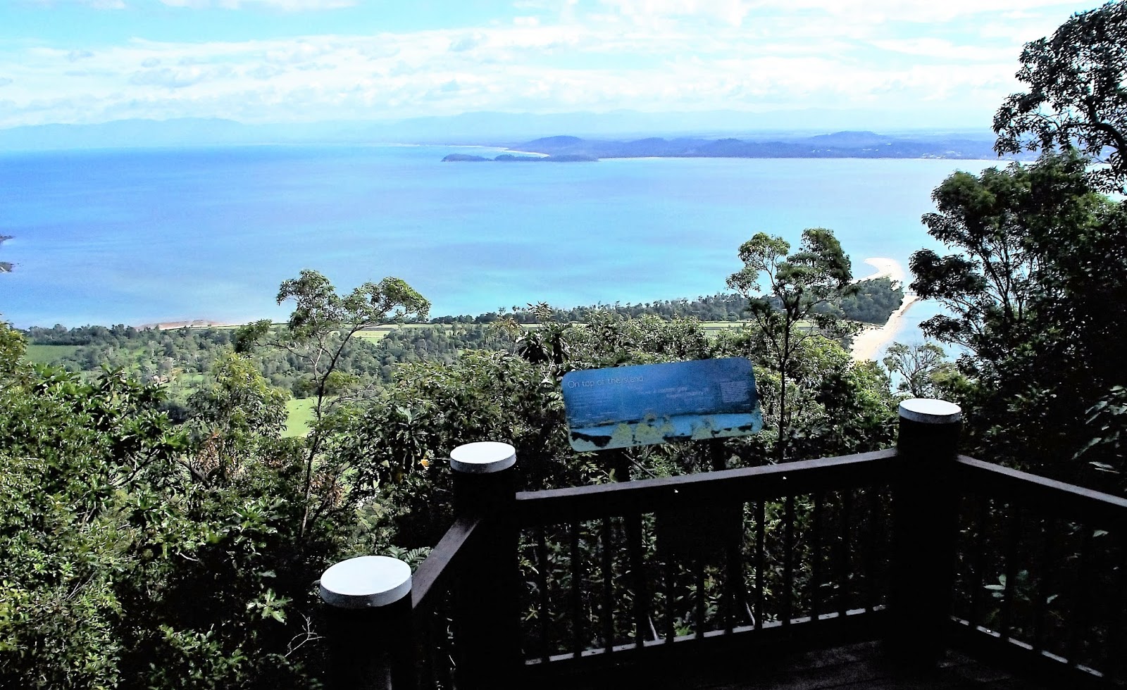
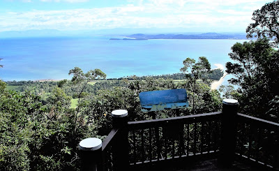
Outlook at the top is pretty good. This is the view due west....

....this to the south-west over LUBBER BAY. Biggest of the nearby islands is BEDARRA ISLAND - another resort island (with an operating resort).
This is such an improvement - when I first came up here over 10 years ago all I could see were the trees around the summit. Somebody, either THE RESORT or QUEENSLAND NATIONAL PARKS, has done a lot of work.

Viewpoint board explains what you are looking at and how landscape was shaped.Also info boards up here about the old radar station and a bit of left over machinery. Click-expand for details.
LONG DISTANCE
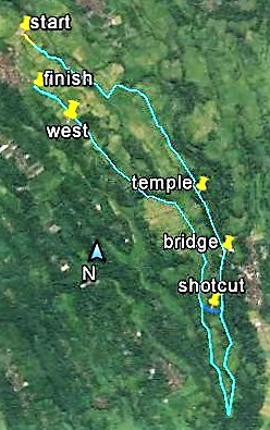
- THE ISLAND CIRCUIT TRACK

This is a big one - the full loop is just over 9km - say 3-3.5 hours.
The first section is the uphill part of the VIEWPOINT TRACK - however soon after you begin descending on the southern part of the summit circle, take the well marked track off to the left towards the south-central part of the island. This descends thru PALM VALLEY to hit the west coast at COCONUT BEACH. It turns west just behind the beach, does another turn and starts heading back towards the north behind the mangroves and along PALLON BEACH. Crossing THE SPIT near the pier, it does a last leg along BRAMMO BAY.
DON'T BE TEMPTED TO SHORTCUT - the airstrip and resort are private property and are patrolled.
SLOPES - the downhill section to COCONUT BEACH has a lot more distance to lose height compared to the first section up to the viewpoint and so slopes mainly vary between gentle and moderate. Maybe a few short stretches of fairly steep. Doesn't matter all that much on account you are going downhill if you do a clockwise island circuit.
At the south west corner of the walk (the western end of COCONUT BEACH) there is a very short stretch reaching properly steep status with a few quick stairways. Behind the mangroves and along the beaches is flat.
SURFACE - the downhill section is pretty good underfoot. There seemed to be more vegetation detritus underfoot than the previous uphill section. Towards the bottom were a few roots and these became more common in the section behind COCONUT. Ditto stones etc. But not a difficult section underfoot. The section behind the mangroves is very good. PALLON BEACH can get a bit skinny at full tide and soft sand at the top of the beach made walking a bit difficult. A huge fallen tree forced a wading detour out into the water. THE SPIT and BRAMMO BEACH are easy.

Start of the descent - slope and surface not too challenging, rainforest nice.

PALM VALLEY - I got the impression the area is still recovering from TROPICAL CYCLONE YASI - it was nowhere near as lush and dense as when I first visited.
THE RESORT
DUNK ISLAND RESORT has been closed since being cleaned up by TROPICAL CYCLONE YASI in Feb 2011. That's a hell of a long time out of action. Rebuilding is going on at a pretty gradual rate. There seem to be a few rebuilt areas that are operational - apparently these are for the use of the owners' relatives and friends. The resort is closed to the general public.
 Not much has been done to this section of the resort since Yasi. About 70% of other buildings seemed similar in July '16.
 This small section behind the eastern end of the beach seemed to have been refurbished - a few lights showing at night.
 The reception pavilion looked as new too, as did the pool. I read the pool was completely covered with sand washed in from the beach by the cyclone's tidal surge.
THE CAMP GROUND
DUNK's nice little camping area is NOT closed - and like my previous visit this is where I stayed.
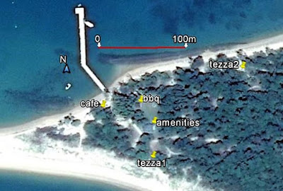 The small campground is nicely positioned close to the spit and just off the island's pier. I found my (1st) spot and was setting up 5 minutes off the water taxi.
There are 8 small tent sites immediately behind the beaches and one central group site. All are connected by concrete paths thru the bush.
The DAYTRIPPERS' AREA is immediately adjacent and its facilities are used by the campers too. So we have a bbq area, picnic tables and an amenities block with HOT SHOWERS.
Hey, this cost me $6.50 a night. Contrasr -FITZROY ISLAND camping cost $35 and had cold showers.
DUNK campground is owned by QUEENSLAND NATIONAL PARKS and you need a permit - but this is dead easy to get. Actual booking seems to be handled by an online branch of the RESORT and was straightforward. It looked like the resort was handling cleaning too.
More info - https://www.dunk-island.com/index.php/camping
THE RESORT
DUNK ISLAND RESORT has been closed since being cleaned up by TROPICAL CYCLONE YASI in Feb 2011. That's a hell of a long time out of action. Rebuilding is going on at a pretty gradual rate. There seem to be a few rebuilt areas that are operational - apparently these are for the use of the owners' relatives and friends. The resort is closed to the general public.


THE CAMP GROUND
DUNK's nice little camping area is NOT closed - and like my previous visit this is where I stayed.

There are 8 small tent sites immediately behind the beaches and one central group site. All are connected by concrete paths thru the bush.
The DAYTRIPPERS' AREA is immediately adjacent and its facilities are used by the campers too. So we have a bbq area, picnic tables and an amenities block with HOT SHOWERS.
Hey, this cost me $6.50 a night. Contrasr -FITZROY ISLAND camping cost $35 and had cold showers.
DUNK campground is owned by QUEENSLAND NATIONAL PARKS and you need a permit - but this is dead easy to get. Actual booking seems to be handled by an online branch of the RESORT and was straightforward. It looked like the resort was handling cleaning too.
More info - https://www.dunk-island.com/index.php/camping


No big deal with me - although I would have liked something hot to eat and a nice cold beer at the end of the day.


3 or 4 picnic tables nearby - hidden by the dark.
THE WEATHER CHANGES
My first day on DUNK was real nice - sunny, warm and moderate south-easterly trade winds.
But around 3am next morning it did a turn for the worse - a LOW PRESSURE TROUGH hit, turning winds to the south west and intensifying them greatly. For the next 3 hours til sun-up my tent rocked and rolled, threatening to take off for OAHU.
So first light I switched to the sheltered lee side of the camp area.

I had my pick of all 4 sites on the BRAMMO BEACH side (the 2 campers there had packed up and left quite early). This is #3, a nice site a bit further from the amenities block but with even closer beach access and room for about half a dozen tents my size.
This second camp site was still a bit blowy but not bad
– until as darkness fell it started to RAIN PRETTY HARD and got REAL COLD.
I don't like reading in a cramped humid tent. No lights or shelter elsewhere in the camp area, the daytrip tables had no lights or shelter, the bbq set up had okay lights, limited shelter but a million big green ants running around where I wanted to sit and the amenities block was a bit smelly for more than a few minutes stay. So I turned in around 7.30PM – but being
a geezer and only needing 3-4 hours zzz a night I was awake by 11PM. That was
one loooong, cold, wet (condensation) night.
Next morning I packed up the wet
tent (I HATE THAT!) and caught the first boat off the island – way earlier than
originally planned.

Breakfast before the boat. Check the standing water. At least the bbq facility had shelter from the rain. Check those puddles.

Heading for the mainland - if you click-expand you will see the rain on the windscreen.
I wrote a trip report for TRIP ADVISOR titled "WHEN THE GOING GETS TOUGH, THE TOUGH ---- VAMOOSE".
I wrote a trip report for TRIP ADVISOR titled "WHEN THE GOING GETS TOUGH, THE TOUGH ---- VAMOOSE".
OK, I wimped out. But I have to say I enjoyed my short stay, and the bad weather has made it more memorable.
One thing's for sure - DUNK is a very nice island.
GETTING THERE
 I went across to Dunk with MISSION BEACH DUNK ISLAND WATER TAXI (07-4068 8310) which has an office opposite this launch site on WONGALING BEACH.
The trip didn't take much more than 10 minutes and was fairly smooth despite the choppy seas. The driver gave a good safety spiel and had useful information about the island. The office distributes a good map which includes the walking tracks.
The office was well informed - told me that the approaching low pressure trough with its strong winds would whip up appreciable surf on the above beach, making beach launches impossible - thereby cancelling my pickup from the island. But they arranged for an alternative outfit which must run each day due to contracts with the island resorts to bring me back.
DUNK WATER TAXI also has an informative website with lots of good island info.
Cost July 2016 $35aud return for daytrippers - $50 for campers.
One complaint - they don't have a courtesy bus for people without cars. Luckily I was staying in a backpackers' only 15 min's walk up the road.
 I came back from DUNK with MISSION BEACH CHARTERS (07-4068 7009) which launches out of CLUMP POINT HARBOUR further north. Distance to Dunk is about 11km - twice that from WONGALING BEACH - but only took abt 15 mins or so. I'm thinking this outfit may suite movement impaired people more - it's kinda tricky hopping onto a beach-launched boat even in fairly calm conditions.
This outfit's boat is smaller but seems designed for rough conditions and rode the relatively roough seas on the way back well. And DRY, thanks to a very good canopy.
Bec in the office was great. She rang me on Dunk and told me exactly when I would be picked up and then rang my WONGALING backpackers' to arrange for them to send their courtesy van the 10km or so to transfer me on arrival at Clump Point. They were a little late so she rang me again an hour later to ensure I had been picked up.
This outfit can do a lot more than transfer you to DUNK. Check the website.
One thing's for sure - DUNK is a very nice island.
GETTING THERE

The trip didn't take much more than 10 minutes and was fairly smooth despite the choppy seas. The driver gave a good safety spiel and had useful information about the island. The office distributes a good map which includes the walking tracks.
The office was well informed - told me that the approaching low pressure trough with its strong winds would whip up appreciable surf on the above beach, making beach launches impossible - thereby cancelling my pickup from the island. But they arranged for an alternative outfit which must run each day due to contracts with the island resorts to bring me back.
DUNK WATER TAXI also has an informative website with lots of good island info.
Cost July 2016 $35aud return for daytrippers - $50 for campers.
One complaint - they don't have a courtesy bus for people without cars. Luckily I was staying in a backpackers' only 15 min's walk up the road.

This outfit's boat is smaller but seems designed for rough conditions and rode the relatively roough seas on the way back well. And DRY, thanks to a very good canopy.
Bec in the office was great. She rang me on Dunk and told me exactly when I would be picked up and then rang my WONGALING backpackers' to arrange for them to send their courtesy van the 10km or so to transfer me on arrival at Clump Point. They were a little late so she rang me again an hour later to ensure I had been picked up.
This outfit can do a lot more than transfer you to DUNK. Check the website.

------------------------------------------------------------------------------------------------------------
IF YOU SEE MISTAKES OR HAVE EXTRA INFO, PLEASE POST IT BELOW. BUT IF YOU HAVE A QUESTION ABT DUNK, PLEASE ASK IT IN THE FORUM WHICH CAN BE ACCESSED VIA THE INDEX. I CHECK THE FORUM MOST DAYS BUT DON'T REVISIT THESE INDIVIDUAL PLACE PAGES ALL THAT OFTEN.