I'm gonna paraphrase Lady Tezza's
" IF YOU WANT A GOOD BEACH IN BALI, STAY ON THE AIRCRAFT TO THAILAND" with:
IF YOU WANT A GOOD BEACH IN SOUTH-WEST USA, HOP OFF THE AIRCRAFT FOR THE WHITE SAND BEACHES OF FLORIDA (0R THE CARIBBEAN OR MEXICO'S YUCATAN).......alternatively if you are coming from Asia or western Oceana
HOP OFF IN HAWAII OR TAHITI OR FIJI. Of course you could detour to the closer west coast of Mexico, but I reckon you need to be way down the Baja from what I saw of beaches close to Tijuana.
Fact is, the beaches of south-west USA are pretty ordinary.
For a start, they DON'T FEATURE PARTICULARLY NICE SAND ....
THORNTON STATE BEACH in the southern San Francisco area aint gonna win any awards in the white/clean sand competition.
....and tend to have LOTS OF WEED....
....both on the sand such as here at DOHENY STATE BEACH just south of Dana Point in Orange County (greater southern LA area)....will be clearer if you click-expand image
....or here at CARMEL on the trendy central coast between SF and the Big Sur area (twilight shot accounts for underexposure). I have to admit I thought my cruise around Carmel just after sunset was pretty nice - seems a pretty picturesque and laid back place. A bit pretentious maybe.
....and in the water (click-expand to better see the stuff between the people and birds. And all those pelicans cutting a school of sardines to pieces don't particularly promote pristine water conditions). The beach is PIRATE'S COVE, a college students'/naturists' haunt near Avilla Beach in the San Louis Obisbo area.
Actually Pirate's Cove had a lot of other negatives common for many of the beaches - BADLY AFFECTE BY TIDE and BACKED BY HIGH CRUMBLY CLIFFS which make access a hassle and will be the first to come down when the San Adreas moves.
Pirate's Cove has positives too - see down page in the CLOTHING OPTIONAL section.
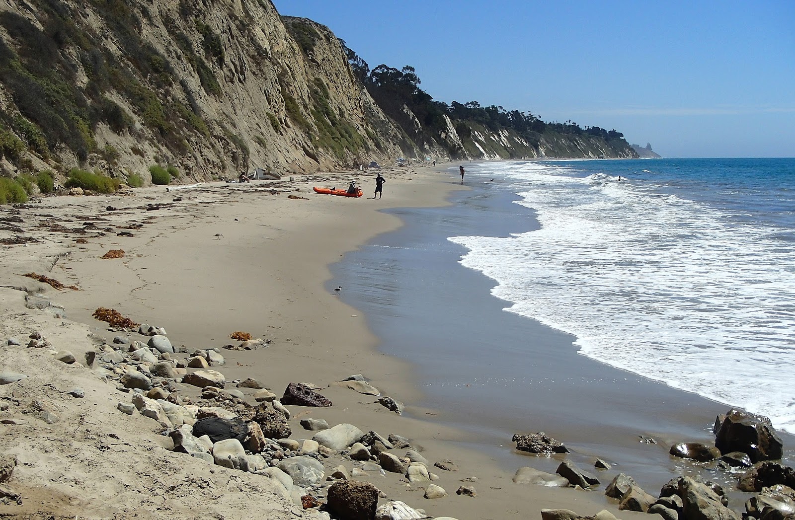
Another where backing cliffs hinder access is MORE MESA BEACH near Santa Barbara. Has the usual allocation of weed plus an extra - small blobs of crude which have leaked from oil rigs not far offshore. At least it was light crude - not that tar-like heavy stuff leaks outa ships.
But the big-kahuna of backing cliffs is at BLACK'S BEACH near the famous Torrey Pines golf course/Salk Institute just north of La Jolla (say La Hoya) in the San Diego area. These are 100m/300+ft high and take an age to climb down/up - via a very dodgy track at the far end and a better but still exhausting set of rock/dirt stairs just behind the camera on the La Jolla side of the Gilder Port clubhouse-restaurant. At least the parking is good and (unlike so many California beaches) free - the big Torrey Pines Glider Port car park is just behind the beach.
Those cliffs make a great launching pad for hang-gliders, para-gliders and similar. The eagle eyed may be able to see the radio controlled model glider just to the left of the para-glider towards right frame and a small black drone left of center.
I'm not to keen on PAID PARKING either. It's excusable at crowded urban beaches like Santa Monica (where $us78 for large recreational vehicles vs $10 for cars is less excusable), but not so much at.....
....semi rural locations like EL MATADOR STATE BEACH west of Malibu, particularly when there are very limited spaces for what is a popular location (which I found a bit hard to understand on account this is another not so nice beach with difficult access down a crumbling cliff side).
$10 is a bit rich for dudes like me who simply want to check the beach - fortunately I was in my pre rental-car phase here and bused/walked to this location. That's the Pacific Coast Highway (PCH) at top - the nearest bus from the LA area arrives at Trancas about 4km to the right of frame....
....or completely isolated beaches like PFEIFFER STATE BEACH on the Big Sur coast. Once again very limited parking for a popular beach - so much so that a ranger at top of the access road was stopping motorists venturing down the very narrow 3.5 km Sycamore Canyon road from the PCH. I wish he had stopped me (I had my rental wreck by this stage) - $us10 for a 30 minute check of another very ordinary beach (well the rock formations are not ordinary) was poor value.
I felt sorry for my neighbours at Pfeiffer Big Sur National Park camping area - from inland Phoenix, they just wanted to walk on a beach but were turned away by the ranger. I directed them to GARRAPATA BEACH 27km to the north (see down page), not a better beach but with at least free parking alongside the PCH - a bonus is they had the wonderful scenery of the Big Sur coast along the way. And they did get to walk on quite a long beach (people like me who live 3 minutes from the nearest of 5 beaches in my town take walking on the beach for granted).
I'm also underwhelmed by NOT SO CLEAN WATER. At only one beach could I see my feet in one meter of water - La Jolla's Black Beach pictured up page.
I know a lot of unclear sea water comes from stormwater pollution which you'd think would be minimal more than midway thru California's normal dry season in what is about the 3rd year of drought. So it looks like the murky stuff I saw is down to other run-off from heavily populated areas. After all, California has 39m people which makes my NSW which is appox. twice the size with only 7.5m people seem small time. No wonder the water is clear at home most times.
I can't show you any shots of unclear water, but the above, the snorkeling area at LA JOLLA UNDERWATER PARK, La Jolla Point only 3km south of Black Beach has similar clear stuff according to some nice Brit girls in my dorm at the Ocean Beach backpacker joint. But they mentioned being scared out of their wits by some cruising sea lions/otters. Now I'm no sissy, but I'm not particularly keen on being bumped by an inquisitive 200 kilo critter. And my earlier observations at San Francisco's Pier 39 is they tend to get ornery.
COLD WATER AND LACK OF SUN. The guide books tell surfing visitors to get a wet suit even for summer. Now I'm a wimp when it comes to cold water (in my youth I'd surf thru winter in the days when wet suits were expensive and we were dirt poor - a football jumper was an inadequate substitute. That has ruined me for cold water for life).
But I'm lucky - summer 2015 was a warm water one for California. Even at San Francisco it felt bearable to me - the further south I got, the better.
Similarly the books say San Francisco, Santa Cruz/Monterey and Big Sur visitors should not be surprised by lots of cloud/fog on summer days. I got sunny days the whole time I was in the area. Further south of course, sunshine rules in summer just about any year.
Not too much cloud/fog here.
I'm hard to please. I'm also not whelmed with LOOOONG WIIIIDE BEACHES which I personally find featureless and a pain to cross (sometimes literally - the sand can get real hot in mid-summer). I like compact, narrowish beaches book-ended with headlands and preferably backed by forested hills or at least a park, not housing/shops/roads etc and certainly not crumbling cliffs.
Long and wide - this is looking south from the famous HUNTINGTON BEACH pier which is about half way along the strip of sand which runs more or less continuously 38km from Long Beach (the name fits) to Newport Beach's Balboa Peninsula in Orange County.
At least the local authorities groom the beach of seaweed and other litter.
The L A South Bay beach is a similar looong-wiiide strip which runs 43km from Will Roger's Beach 7km north of Santa Monica to Torrance Beach in the south. This is the outlook from the HERMOSA BEACH pier about 2/3rds the way from Santa Monica. You are looking at less than 20% of the strip in this shot.
OVER REGULATION.
America is supposed to be THE LAND OF THE FREE, but I have never seen so many beach signs forbidding people to do stuff. In most cases this still left visitors able to walk, swim and lie on the sand - but some Big Sur locations didn't even allow that! Of course, this is down to the authorities being gun-shy from too much public litigation. The USA would be a lot more relaxed place if they deported the lawyers.
THE ONES I LIKED
This is WESTWARD BEACH a few km north of central Malibu. Past that narrow bluff in the background it becomes the similar but longer/wider ZUMA BEACH. You can see Westward meets my criteria of being not too long and bookended by bluffs/headlands. And not too wide. It also had a nice atmosphere - lotsa families and summer camp kids enjoying the last week or so of the school holidays plus a few surfer dudes.
And Westward's sand was reasonably clean, with only minimal weed at the high-tide mark.
Westward's eastern headland (POINT DUME) has great 270 degree views - above looking further east along the Malibu coast. Santa Monica was hidden in the haze out of frame to the right.
For what it's worth, I'm classing Westward Beach as southern/central California's best beach.
This is the legendary surfing spot of WINDANSEA, a few km south of La Jollla Point. Hell, when I was a surfer-grom in the late 50s, this place was legendary. I had a second-hand surfboard made by some dudes (can't remember names/ we are talking nearly 60 years ago) at Windansea and the place featured in just about every surfer movie we used to travel miles to see back in the day.
Note the relatively good swell. I reckon the general San Diego region tended to catch more summer swell than most Calif places (but winter is normally the best time for California swell).
And Windansea seemed to catch more than other San Diego locations.
Um -- I feel a bit guilty about not going into the water. But the thing is, I was less than half way thru my bicycle trek up to Black Beach (plus I had to ride back) and I'm guilty of over-concentrating on the task at hand - keep on keeping on. So shoot me.
Above is TORRANCE BEACH at the far southern end of the LA South Bay bike trail. As mentioned above, I was less than impressed by the long, wide South Bay beach but the southern end at Torrance sees it narrow and backed by the rather impressive Palos Verdes headland. Plus it had a good vibe - plenty of svelte young people in Speedos doing some sort of lifesaving stuff a la Australian Surf Life Saving, and no shortage of surfer-dude/dudette types.
My 65km (return) ride from the Santa Monica pier along the South Bay bicycle trail had a somewhat comical outcome - I'm no stranger to that sort of distance, but the rental beach cruiser had a very broad saddle and laid back peddling position compared to my triathlon bike at home - when I got back to Santa Monica I was in considerable pain and discovered I'd worn the skin off my butt-cheeks. Cut-off denim shorts worn commando style instead of sensible cyclist stuff didn't help.
I couldn't sit down for 3 days which led to some hilarity at my backpackers' and on buses, and I had to ditch any biking plans for nearly 3 weeks which made getting around at Long Beach, Orange County, the Grand Canyon rim, Yosemite, San Francisco, Monterey, Big Sur, San Luis Obispo, Santa Barbara, Ventura and San Diego more time-consuming or expensive than I'd planned (the plan entailed buying a $40 beater at Long Beach, taking off the front wheel and throwing it in the back of my rental hatchback, riding around at most of my stops and giving it to some kid at the end of the trip).
Note the sand in the above shot - about the closest I got to white stuff in California. This was shot at PLAYA DEL RAY just south of LAX and about half way along the strip. Strange on account there is a big sewage treatment plant just behind the beach here.
Sand colour varied markedly along the South Bay trail - at Venice Beach further north it had a distinctively grey tinge.
Note beach width in the above shot. Better take a water bottle on that trudge to the waves. And some French legionaires.
South of Orange County's Balboa Peninsula the coast starts a series of smaller bays and beaches - dozens of them. Without a bicycle, I couldn't check them all but MAIN BEACH at LAGUNA BCH seemed pretty okay to me, similar in style to Westward Beach. Okay, maybe longer,wider and a bit more urban than my ideal, but as said, pretty okay. The main street area had a funky beach town feel but it tended to be a bit too upmarket/trendy to beat southern/central California's top beach town places as outlined below.
TOP BEACH TOWNS
Surfing started in Hawaii but California developed the surfer lifestyle and those funky surf towns.
I give top rating to Orange County's HUNTINGTON BEACH. The main drag goes 300m inland from the famous pier and has a mix of surf shops, bars, snack bars and restaurants plus the expected number of surfer dudes and wannabe wahines hanging around.
Town area from Huntington pier. Those businesses have spread along the PCH which runs just behind the beach. Naturally the area has gentrified with some flasher retailing and upmarket accommodation, but it still retains its surfer-town vibe.
Another great beach town is San Diego's OCEAN BEACH. The main drag, Newport Avenue, had all those old time surfer hangout features including this swb 60s Kombi surf-wagon.....
...a funky 60's style backbacker/surfer hostel (Ocean Beach International Hostel) with a very relaxed friendly vibe...
....and a cool upstairs bar deck at the beach end where you can sip $3 happy hour craft beers** in 16oz glasses (a US pint but at 473ml abt 80% of a Brit pint) while watching the sunset.
**I thought craft beer was for pretentious wankers until I tried those in California. Wow, how wrong was that! And what gets me is how each bar seems to have about 20 on tap.
btw nearby MISSION BEACH and PACIFIC BEACH seemed very similar in character to Ocean Beach. No wonder San Diego is my favourite south-west USA bigger city.
Contenders which didn't make the cut:
SANTA CRUZ didn't seem to have much going on (it may be a bit more lively later in the day than my 11am visit - and when the college kids return to term); SANTA MONICA and SANTA BARBARA are too upmarket and aimed at non-budget tourists; and funky VENICE BEACH was downmarket and aimed at all tourists.
CLOTHING OPTIONAL BEACHES
If you have checked my SPAIN pages will you know I've been a naturist since the 60s. But the bad news is central/southern California is no Spain. In fact the clothing optional beaches are as underwhelming as the beaches in general. Here are my observations of maybe half a dozen clothing optional beaches from north to south:
BAKER BEACH SAN FRANCISCO
This beach is maybe SF's premier naturist location. You would think in a city which has a reputation as a laid back, free lifestyle location the beach would be pretty popular. Well it was - with textiles. I found the naturists were confined to a small group of maybe 20 or so scattered around the far northern end. This was on a Monday afternoon in drop dead sunny conditions (not all that common in SF). But a local told me that if they had those conditions on the previous afternoon (Sunday) there would have been many more nudists.
BAKER BEACH has a great position - less than 2km from the Golden Gate at top of image and 7km from downtown SF and the Fishermans' Wharf area. It took me less than 10 minutes to ride my rent bicycle from the bridge after crossing to the other side and checking trendy/pretentious (but kinda nice) bay-side SAUSALITO on the other side.
This is a reasonably long beach at 1200m - the naturist area is at the northern end (far left of image) although a bunch of textiles were up there when I visited. Maybe they'd heard the cut Tezza torso would be there. We are looking just slightly south of due west here - downtown (the CBD office area) is top-left of image.
Both images are modified Google Earth on account my camera battery was dead at this stage.
btw, the beach itself was the typical weed-covered not-too-white or yellow California thing - but the weather was uncharacteristically not cloudy or foggy (lovely sunny afternoon actually) and the water even more uncharacteristically non-chilly. Not all that clear though.
BONNY DOON BEACH
This is alongside coastal Highway 1 about 110km south of the Golden Gate and only 10km north of Santa Cruz. A nudist at Baker Beach said Bonny Doon was THE place, but not on this real nice late Wednesday morning - the northern nudist section above was devoid of nudists. The beach itself was nothing to write home to mum about. I didn't stay, particularly when the web-sites warn about theft from cars at the (no charge) roadside parking area.
GARRAPATA BEACH
This is a northern Big Sur beach about 12km south of trendy Carmel. It is fairly long at 1000m, backed by the typical crumbly cliffs. The naturist area is again at the far north end, a fair old hike from the car parking area alongside Highway 1 (the wider section adjacent the south of the beach).
I shot this from the northern end - as you can see there are few beach-goers on a real Wednesday nice mid-afternoon. No naturists. The beach itself had more weed and was less clean than the shot may indicate. Ditto the sea.
PFEIFFER STATE BEACH
This mid Big Sur beach is found down a narrow access road from Highway 1 and is about 6km from my Pfeiffer Big Sur National Park campsite and the nearby Big Sur Lodge. As said up page, the too-small parking lot has a $10 charge. This beach too featured mediocre sand and plenty of weed, but those rock formations tend towards the spectacular. The beach certainly had a crowd when I called in late on a nice Thursday morming, so much so that the nudist section at the far north end was crowded with textile families, making it kinda anti-social to sun the bum. I didn't stay.
Once again my camera battery was empty so I pinched this image off Google Earth. That red line towards image bottom represents 500m.
PIRATES COVE
I have a pic of this not too attractive beach up page. But it is the one naturist location I really enjoyed. Mainly because the southern half had a good crowd of nudists making me feel I was not offending anyone being naked and partly because on returning from a swim in the very weedy water I found Kara and her man had squeezed in next to my spot. "I hope you don't mind us being here, but there's not a lot of room" said she. I didn't mind on account Kara was not only a very attractive 30s something lady but also bubbly and talkative which was just the ticket after 3 weeks of solo travel. Some of you dudes are probably thinking where's Lady Tezza? Thing is, The Lady has a chronic illness which makes flying more than 8 hours very uncomfortable - we can't afford to break long flights into legs. So THE LEADER OF THE HOUSE gets to go on most of our shorter Asian trips - plus she has discovered a very good value pleasure: short cruises out of Sydney into the South Pacific.

Pirates Cove is 17km by road from the rather nice town of San Luis Obispo and 2km as the crow flies E of the touristy Avilla Beach. S L Obispo is a college town among other things and the left half of the above beach tends to be the college kids'area- the right the naturists' although there is some overlap. Even though term had not quite begun there was a fair crowd of undergrads drinking beer, throwing ball and in general having a good time. It struck me that American college kids see their time as the last chance to enjoy adolescence whereas university students in my country tend to act adult, too serious and a bit pretentious. Few of the college kids on the beach were nude.
Pirates Cove has a too-small and very rough-surfaced dirt car park high on the headland just left of frame. Dozens of cars were forced to park along the narrow access road where NO PARKING signs indicated a potential windfall for the local cops. The walking track from the car park down to the beach is steep enough to be a good workout but not difficult underfoot.
The distance line on the above image represents 250m. Check out the kelp in the water.
MORE MESA BEACH
I have a pic of this beach up page. It is the one where I moan about the high backing cliffs and light crude oil in the sand.
More Mesa is about 12km by road west of central Santa Barbara. It is 15 minute walk from the nearest legal parking on distant Vieja Dr - you have to slog up a wide road with gated estates both sides and NO PARKING SIGNS, then cross a wide barren field on that track running under the a in Mesa and finally climb down a set of stairs. The beach itself is as I said up page not particularly attractive and is uncertain in length, disappearing out of frame towards Santa Barbara. But Google earth shows it narrows to next to nothing about a km out of frame. The naturist end is to the left of the access steps, particularly the far left but there were only about 3 nudists on a very nice late Sunday morning. There was a bunch of textiles to the right of the access steps and a bigger group way right where I think there may be other access from those housing areas.
I forgot to add a distance line. It is 1200m in a straight line from the "N" place marker to that of "parking".
EL MATADOR STATE BEACH
I have a Google Earth view of this very ordinary beach's expensive and tiny car park up page. I couldn't understand this fringe western Malibu strip of silica's popularity - the much nicer Westward and Zuma beaches begin only 6km to the east. The naturist section is past that big rock far right, but....
...it had a bunch of textiles, no nudists on a nice Friday morning in the school holidays. Now I have nothing against textiles - when nudists share a beach it is up to them to arrive early enough to stake out their area - which keeps most textiles in other parts of the beach. Except in Spain and the Greek islands, where they mix indiscriminately, even on the sun-lounges.
BLACK'S BEACH
I have a pic of this beach from the top of its "big kahuna" cliffs up page. The above Google Earth image shows the glider port, its big dirt car park, the Torrey Pines golf course, the stairway just south of the glider port and the decidedly dodgy northern access track which smart people should avoid. This is another of those beaches which seem to extend miles out of frame, but nudists were spread along the 900m between the two access tracks - with a concentration spreading several hundred meters near the southern stairs, which makes sense. There seemed to be textiles about 500m out of frame to the south.
The beach had about the same number of nudists as Pirate's Cove, but the dispersal over a much bigger distance made is more impersonal. Cynics among you are thinking I missed the Kara factor. You are not wrong. This is actually a better stretch of sand than at Pirates Cove, although once again nothing to write home to mum about. I came across a tendril of kelp which was as thick as my leg and at least 15m long. I read somewhere kelp off the California coast can grow 1M in a day.
The glider port's clubhouse/snack bar deck has a great outlook. That's San Diego's La Jolla Point in the background. The above area is 8km by road from La Jolla Point and 25km from downtown San Diego.
MOST EXOTIC BEACH
This is Rosarito Beach, 38km south-west of Tijuana's main tourist strip Centro. Regular share taxi vans shuttle between the two for $2. I'm classing this "exotic" simply on the basis of its Mexico location. Sure it was a bit different with dudes offering pony rides and cool on-beach bars with cheap and rather good Mexican beers, but the beach itself...
....was no great shakes - long, wide and not so clean like so many north of the border, although....
....I wasn't complaining.
Tijuana is so easy to reach from San Diego - you can get to the border from downtown on a 28km inexpensive trolley (light rail) ride. Centro is a well -signposted 15 minutes stroll from customs/immigration. Centro has a dodgy reputation with some but I found it a kinda much more organised, cleaner version of Kuta Bali's central shopping area with way less hassle from locals.
My thanks to Tanya, the super-informative Ocean Beach International Hostel staff member with the world's best 40 year old legs who told me about Rosarito and the $2 share taxi vans. The ride was fun - locals tend to use the vans as a jump on - jump off bus service - but the suburbs of Tijuana sure are dusty and dirty. Then again, this is a semi-arid area in about the 3rd year of drought and the Mexicans haven't the tax base to harvest/poach water like the Californians.
I notice Google Maps classify Rosarito as a Baja beach, but I think you need to be a fair distance south to hit the picture post card white sand ones seen in surfing movies and travel posters..
IF YOU SEE MISTAKES OR HAVE ADDITIONAL INFO PLEASE MENTION THEM BELOW - BUT PLEASE DIRECT ANY QUESTIONS TO THE FORUM SECTION - I DON'T LOOK AT THESE INDIVIDUAL PAGES VERY OFTEN BUT I CHECK THE FORUM MOST DAYS.


1 comment:
Wow! "Tezza's Beaches and Islands"
Great blog, thank you for sharing & Post more blog posts.
Best Beaches in Israel
Post a Comment