THE GAME ISN'T OVER WHEN THE FAT GUY KISSES THE SCHIST

Listen up. All those DONT'S National Parks put up about hiking the Grand Canyon are aimed at blokes like big Bob from Biloxi with his bountiful beer belly – dude might have aced a below-rim walk 10 years ago when he was a BCU linebacker, but that was then – these days he’s gonna be the first to head-butt the trail on account he aint exactly in good condition. And Canyon rangers are less than whelmed hauling 250lb dudes onto the medivac ‘copter.
Hence their warnings – DON’T go more than one hour below the rim,
DON’T go below the rim at all in summer, DON'T be on the trail between 1000 and 1500 and DON’T go alone. Well at one
month short of my 70th birthday I ignored all that. I was below the
rim for over 9 daylight hours traveling some 14 miles (23km). So your big Grand Canyon
trekking plan is not necessarily out the window - I’m sure most of you can do
similar with adequate preparation.
First the negatives: it was a
hot day in mid August. Like many geezers my knees are dodgy from too much jogging
when young and my feet are not in particularly good shape – some arthritic
bumps, and a few gnarly toe nails point in the wrong direction. I’m not a
regular trekker. I live at sea level and have no idea about the impact of
altitude. I’ve never trekked the desert but I’m no stranger to hot days.
The positives: I’m used to
exercising in hot humid conditions which I reckon are just as trying as very hot dry
ones. I’m extremely fit from daily swimming and cycling and decided to work on my
trekking with some pretty hard one to four hour walks around my super hilly
home town every second day loaded down with about a gallon (4 L) of water and
some eats. I have to tell you, water is heavy stuff. At the end of 3 weeks of
this I was so fit I had muscles on my boogers. I'm normally one of those dudes look like an overtrained, underfed greyhound but at the end of all the extra work I people were mistaking me for Iggy Pop's pop.

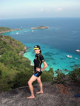
Hey, maybe not his pop. I just read Iggy is almost as old as me. Kinda looks it. So picture this dude with white whiskers, a buzz cut and an even more beat up head, and you have the....um....picture. That arm bandage looks a bit dodgy (image TwentyFourBit)
I invested in a good pair of
mid-range trekking shoes and some cushioned hiking socks, trekking poles and a
hydration pack. Sipping every few minutes without interrupting progress is the
way to go. I also had plenty of electrolyte. Plus trail mix and a couple of commercial power
bars which I munched frequently whether hungry or not. Altitude proved no
problem – maybe because I had two days in nearby Flagstaff plus the previous
day trekking the Canyon rim trail for nearly 7 hours to acclimatize.
An important point - I trimmed my toe nails as short as possible. Even good-fitting shoes will see long (or even ordinary length) nails banging up against the front on sustained steep downslopes - they can get miserably sore.
THE ROUTE.
One DON'T I didn't ignore - DON'T try to hike down to the river and back in one day.
It wasn't that I thought I couldn't do it with adequate preparation - more the fact that I didn't want to wreck myself up on account I had some big treks planned for Yosemite and Mt Whitney in the following week. Plus I read the whole thing takes 15 hours** and I wanted to be on the (return leg) upper Bright Angel Trail before dark - there are some killer views up there.
**Having done maybe 3/4 of a river-return I reckon 11/12 hours is more like it.
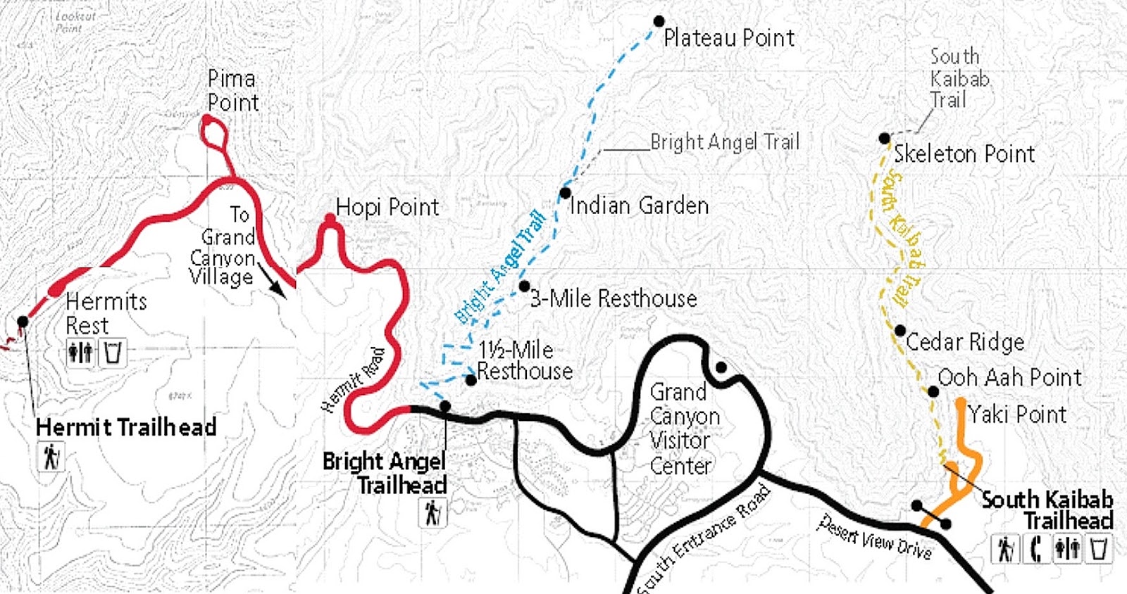
So I decided on a truncated deep canyon walk - down the South Kaibab Trail to the Tonto Platform which is about 70% down canyon, across the Tonto Trail to Indian Garden, and then back up the Bright Angel Trail to the rim.
 Map's red route shows the full river-return loop but you can see the Tonto Trail meandering its way between the 2 main trails (it actually continues both sides for a good 50km+)
All the experts advise going DOWN the Sth Kaibab on account it has no water, very little shade and is steeper than the Bright Angel. The latter has water at 3 places on the ascent and far more shade from side canyons (image HikingOC)

For more detail this topographic map of the area does nicely - if you go to the original at http://files.meetup.com/1554500/GrandCanyon_BrightAngel_Kaibab.jpg it click expands nicely once open.An important point - I trimmed my toe nails as short as possible. Even good-fitting shoes will see long (or even ordinary length) nails banging up against the front on sustained steep downslopes - they can get miserably sore.
THE ROUTE.
One DON'T I didn't ignore - DON'T try to hike down to the river and back in one day.
It wasn't that I thought I couldn't do it with adequate preparation - more the fact that I didn't want to wreck myself up on account I had some big treks planned for Yosemite and Mt Whitney in the following week. Plus I read the whole thing takes 15 hours** and I wanted to be on the (return leg) upper Bright Angel Trail before dark - there are some killer views up there.
**Having done maybe 3/4 of a river-return I reckon 11/12 hours is more like it.
So I decided on a truncated deep canyon walk - down the South Kaibab Trail to the Tonto Platform which is about 70% down canyon, across the Tonto Trail to Indian Garden, and then back up the Bright Angel Trail to the rim.

All the experts advise going DOWN the Sth Kaibab on account it has no water, very little shade and is steeper than the Bright Angel. The latter has water at 3 places on the ascent and far more shade from side canyons (image HikingOC)

THE SOUTH KAIBAB TRAIL
I deliberately ignored all the advice about a sunrise start [this gets trekkers off the trails (if they are not trying the full river loop or my truncated route) before it gets too hot]. I didn’t want to haul myself out of my sleeping bag at 4am - it can get real cold (near freezing before the sun gets a chance to warm things up) in a tent up on the high rim even in August.

Plus I figured a later start would ease the temptation to keep going past the Tonto junction to the river, on to Phantom Ranch and then back up the Bright Angel Trail – as said that would entail a longer hike and perhaps wreck me for several big upcoming treks. Or miss the great views on the upper Bright Angel due to darkness.
For the same reasons I took my car to near the Kaibab trail head rather than the shuttle bus That would force me to be out of the canyon reasonably early so as not to miss the last shuttle across from the Bright Angel trailhead to retrieve the car – I didn’t fancy a 3+mi/4.8+km walk after more than 8 hours in the canyon. As it turned out, parking problems saw me dump the rental about a mile from the Kaibab trail head – what’s an extra mile at the start of a 14 mile trek?
Once at the trailhead I topped up my water supplies and hit the track at 8.36 am.
Kaibab trailhead is slightly higher than Bright Angel’s at 7200ft/2195m and the walk to the Tonto Trail junction at 4000ft/1220m is a bit shorter at 4.4m/7.1km, making the Kaibab steeper on average than the Bright Angle - considerably so in parts. It is also rougher, particularly around O’Neill Butte and below Skeleton Point, but I wouldn’t call any section unpleasant underfoot and I have dodgy knees/feet. Because the trail mainly sticks to a ridge the views are arguably better than Bright Angel’s side canyon route, but I found the latter hardly shabby. There is way less shade and no water the whole way to Indian Garden 8.8mi/14.3km from the start. So bring a fair bit. I had just under a US gallon/4L. I was surprised there was still nearly 2L left at Indian Garden.
Despite the fact I’m no
Speedy Gonzales I reached Ooh-Aah Point pretty quickly – it’s only 0.9m/1.5km and a drop of 600ft/190m – there is
no sign but you know you are there because the view widens into ooh-aah status. There are great views nearly all the rest of
the way but Cedar Ridge (1.5mi/2.5km from the top – 1140ft/350M below the rim –
reached in 55m and Skeleton Point (3mi/4.9km –
2060ft/630m – 1hr50m) are standouts – Skeleton Point gives first view of the
river. There is a restroom at the former.

Fellow trekkers take a rest at Cedar Ridge. Opening shot up page was also taken from this area.

Shortly after Skeleton Point
I hit these numerous and rather steep switchbacks.
This section has probably the roughest track conditions underfoot but not what
I would class a hassle. Lots of rock and timber step-downs, mainly single although often close but I can’t
remember any steep stairways. And very few of the step-downs had big knee-wrecking vertical drops. I think you can begin to see why the experts recommend going DOWN the South Kalib. The Bright Angel has some great switchbacks, but the gradient is less than the above.

The second of two mule trains I met during my nearly 3 hours on the South Kaibab. The first was carrying baggage - above we have a bunch of people returning from overnighting at Phantom Ranch.
 Dude in charge was stopping frequently to give detailed info to group - they must have left the ranch real early because they were not making fast progress - although faster than I could walk out. Hey, Biloxi Bob can make it down and back this way (at a price).
There was only a moderate number of people heading down the track (probably more with a sunrise start) - I winced at the 4 joggers who overtook me: hope they don’t end up with knees like mine (you know that old dude you see fanging around your shopping center on a sit-down skateboard using hands for propulsion – the one who is always getting busted by the cops for biting pretty girls and security goons on the knees? He was a canyon jogger).
 Whoa! These maniacs run back up too - not as hard on the knees but pretty taxing on the fitness. I remember I use to run hills on my treks back in the day - none with the length of these though. I was a bit slow with my camera on the joggers - had to borrow this from 123RF.

There was only a moderate number of people heading down the track (probably more with a sunrise start) - I winced at the 4 joggers who overtook me: hope they don’t end up with knees like mine (you know that old dude you see fanging around your shopping center on a sit-down skateboard using hands for propulsion – the one who is always getting busted by the cops for biting pretty girls and security goons on the knees? He was a canyon jogger).


I blocked the urge to go the short distance to the Droppoff with its views of the river because I knew with only a further hour and 1.8m/2.9km walk – 1600ft/490m drop to the Colorado I wouldn’t be able to resist going on down. So I wandered around the rest area, rehydrated and refuelled on trail mix/power bars and then set off across the Tonto Trail at 11.43am.
THE TONTO TRAIL

Straight line distance between the two trails is only 2.2 miles/3.5km but because the Tonto winds back towards the rim cliffs to clear 3 side canyons, total walking length is 4.2m/6.8km.

Please excuse amateurish graphics - I'm still trying to teach myself how to use the PAINT thingy on my basic Windows photo editor.

This may make it a bit clearer

I modified this Google Earth image to show much the same thing, The yellow track is of course the Tonto, white the Sth Kaibab and blue the Bright Angel. The river can be seen top left. The (fainltly visible) flat trail out to Plateau Point leaves the western extension of the Tonto at left.
It's hard to put a linear scale on these images with lots of vertical relief - the straight line distance from the Indian Garden place-marker at left to the Trail junction marker at right is 2.2miles/3.5km

The trail is pretty flat –
the only sustained uphill section was out of the biggest side-canyon but this
will only have Biloxi Bill moaning - and wiiide William moans when he turns over in bed. In the opposite direction the climb out of Indian Garden is similar – btw the Tonto hits the Bright Angel trail at Indian
Garden about 10 minutes south of the water supply/camping/ranger areas.


There is virtually no shade
along the Tonto and apparently it is
often above 100F/38c in summer (felt mid
90s when I crossed) – however the best place to stop for a refresh is at the
halfway point - the western Pipe Ck canyon head
where there are a few trees for shade. Water was running here so if you bring
some purifying tablets you don’t have to carry quite as much from the top to
make Indian Garden. All creek
crossings were easy although snow melt time may be different. There were no problems
with thorns etc which can cause hassles on less-traveled sections of the Tonto.


I arrived at the junction at 2pm - taking out maybe 10 minutes for photographic and refreshment stops the 4.2m/6.8km. had taken me a bit over 2 hours.
I saw no other person on the Tonto.


Indian Garden is a neat little oasis which lines the gushing Bright Angel Creek for over a km. The camping and ranger area takes a small proportion of this.
It is easy to see why the Hopi indians used to farm this area.The lower shot also shows the track out to Plateau Point (top right) and the relatively gentle Bright Angel trail the first few km towards the rim at bottom (looks like 2 tracks but one is the creek)

** 1 liter would have done it but I carried a reserve in case one of the water heads was out of action
I was still feeling pretty good
but resisted the 3m/4.8km return trip out to Plateau Point’s views of the river as I wanted to make the rim
before sunset.
There were few people at Indian Garden. Hikers who leave the canyon bottom and Indian Garden camping area at first light would have been long gone - those waiting for the cool of late afternoon to hike up from the Colorado would not arrive until near sunset. And it is too far down from the rim for most day hikers.
THE BRIGHT ANGEL TRAIL
I started my ascent from Indian Garden (which is 4.6 miles/7.5km below the rim and 1.5m/2.4km above the Colorado River) at 2.40 pm.
The first quarter of the hike out from the Gardens is pretty easy – up moderate slopes beside the creek – even my svelte-challenged mate Kananga (who has never failed to completely surround a 12inch/30cm coconut-cream pie in one sitting) would do this with only one or two pit stops.


els

images Bob's Pixels

The trail itself is in pretty good condition with few rough sections although there is no shortage of those step-ups (fortunately mainly singles – I can’t remember any steep staircases). And the good news is that this late in the August afternoon the I soon enter the shadow of the rim (earlier in the day, side-canyon walls give a fair bit of shade).

I had to tilt the camera to get it all in - should be a good pic to click-expand.


From around the One and a Half Mile rest stop the trail got busier – it was clear that a fair few people were doing an afternoon hike down from the rim. Many were in not particularly good shape and a lot had inadequate water and unsuitable footwear. Unfit most were but they seemed to walk faster than my shuffle - however I soon passed them because of their frequent stops.

I finally topped out at 5.50 pm nearly 9.5 hours after I started at South Kaibab trail head. I was probably walking for 8 3/4 of those.It took me 3 hours (after taking out 5 minutes at each rest stop) to walk up from Indian Garden – that’s just over 1.5mph/2.4kph which is close to my average down the South Kaibab and across the Tonto.

By the time I got back to the
campground, showered and changed it was well after dark. I was busting for a
feed and a cold beer. The only close by was at Yavapi Lodge’s cafeteria – I found it overcrowded, the food
ordinary and overpriced, and to add insult to injury they served me a warm
beer. Hell, if I want warm beer I’ll go to England.
REFLECTIONS
Next day I expected to be
aching all over (an old guy on the rim trail the day before told me I'd be doing the 'Kaibab shuffle' for weeks) but apart from sore feet I felt surprisingly good. All that
training pays dividends.
Could I have done it without
extra training? I think yes, but I reckon I would have suffered later.
Could a
person of normal fitness do it? Um, probably, but they would have to make lots
of rest stops and would wreck themselves up for a long time.
Would under-fit (which
for many is normal-fitness) people do it? No way.
In all cases I’m assuming similar hydration and tucker choices to me.
In all cases I’m assuming similar hydration and tucker choices to me.
Given my extra training, could I have done the full loop to the river and back in a day? I think so, but I reckon I could have ended up with a prolonged case of Kaibab shuffle. Thing is, when I topped out at the Bright Angel rim I was beginning to think I'd had enough of hauling myself uphill - an enjoyable physical challenge was close to turning into a hard slog. To the river and back may have been a few (thousand) steps too far.
Are walking poles necessary?
They were a help on slopes, and later, on a slippery treacherous downslope in
Yosemite they definitely saved me from a fall, but I reckon I could have done
the Canyon without them. However they might make the difference for marginal
trekkers and may be one reason why my knees didn't suffer.
Hydration pack? More a convenience to save time on the frequent
rehydration the experts urge.
Good shoes? I’m amazed how well mine grip a
slippery track compared to normal joggers. And combined with the cushioned
socks and maybe the poles I reckon they helped save my knees.
Hell to come out of that walk without sore knees gave me such a high I needed a step ladder to scratch my arse.
THE RIM TRAIL
 Biloxi Bill and friends should not be disheartened - the very best views of the canyon are from the Rim Trail which winds some 11miles/18km along the south rim. There are about 15 viewpoints along here (plus a heap more unofficial outlooks into the canyon) and for a good deal of the journey the trail is similar to the above - sealed and relatively flat.
Frequent free shuttle buses run along roads in back stopping at all viewpoints - some stops are only in one direction so check the super-useful info sheet you get when entering the park).
Bicycling the rim is popular (hire bikes available in the village) but seldom on the rim trail itself. Shuttle buses have bike racks for Biloxi types who suffer pedal fatigue.
 A few of the western viewpoints are joined by an unsealed rim trail. People with very young kids should maybe avoid. And this is no place for Kananga to have a fainting fit.
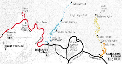 The Rim Trail runs from Hermits Rest in the west toYaki Point in the east. Grand Canyon village is roughly central (image University of Arizona)
There is a bigger, more detailed version of the above with all viewpoints, shuttle bus and other extra info on the National Park website (and you can click it to expand).
 There are so many great outlooks along here it's easy to o/d on them - I liked this westward looking view from Mohave Point on account the Colorado was easily visible mid-distance (click-expand).
But arguably, the very first view most visitors see, Mather Point - a 5 minute well sign-posted walk from the first big parking area after the south gate (main) entrance - is just as spectacular.
 Another nice one - this one is from the one of those many unofficial lookouts on the edge of the rim trail just north of the Abyss viewpoint. I'm thinking the late afternoon time of shot is contributing to the pic.
Late afternoon on the Rim Trail: my dance card that day was pretty full. I left Flagstaff before 0800 in order to arrive at the south entrance to the Canyon early - I'd heard there tends to be big delays later in the day. Around 0900 - no problems.
Drove to the first parking lot, only 5mins walk to the Rim Trail at Mather Point, headed west. Over the next 7+ hours I checked the more than a dozen viewpoints and the way more unofficial lookouts to the west (I managed to cover the ones to the east next day on the way to the Sth Kaibab trailhead for the big down-canyon trek).
I mainly walked the Rim Trail, but used the frequent shuttles to backtrack/sometimes jump ahead. Logistics mean that occasionally I had to double walk a section between viewpoints, and maybe missed walking 2 short sections.
All of this was very time-consuming - by the time I caught the shuttle to the car park and drove to Mather camp ground it was dark. Have I mentioned how I hate setting up tents in the dark?
 Once I set up, I invited neighbouring campers around for a beer.
(image The Mad Men Review)
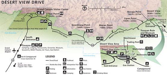
DESERT VIEW DRIVE
Some further rim-top views can be seen along this road which leads from Grand Canyon Village to the lesser used eastern park entrance. I used this to exit the park on account I wanted to cruise Wapaki Monument/Sunset Canyon Drive which loops off highway 89 on the way south to Flagstaff. You can see the loop under UNEXPECTED GEMS 20% from the top of my THE GOOD, THE BAD AND THE UGLY page
 There are 6 viewpoints along this 25mile/40km road - most are pretty good but not a step up from the Rim Trail average. An exception is the last one, nearest the eastern entrance - called simply DESERT VIEW, it singles itself out by being the highest point on the southern rim (7438ft/2267m) with fabulous views to the north and east and having the DESERT VIEW WATCH TOWER (image - National Park Service)
 The tower was built by Mary Colter in the early '30s in the style of Pueblo watchtowers both internally and externally. It is situated near the edge of the rim - the rooftop has really great....
 ....views to the north east. Note river in mid-distance.
 One of several internal levels.
IF YOU SEE MISTAKES OR HAVE ADDITIONAL INFO PLEASE MENTION THEM BELOW - BUT PLEASE DIRECT ANY QUESTIONS TO THE FORUM SECTION - I DON'T LOOK AT THESE INDIVIDUAL PAGES VERY OFTEN BUT I CHECK THE FORUM MOST DAYS.
THE RIM TRAIL

Frequent free shuttle buses run along roads in back stopping at all viewpoints - some stops are only in one direction so check the super-useful info sheet you get when entering the park).
Bicycling the rim is popular (hire bikes available in the village) but seldom on the rim trail itself. Shuttle buses have bike racks for Biloxi types who suffer pedal fatigue.

There is a bigger, more detailed version of the above with all viewpoints, shuttle bus and other extra info on the National Park website (and you can click it to expand).

But arguably, the very first view most visitors see, Mather Point - a 5 minute well sign-posted walk from the first big parking area after the south gate (main) entrance - is just as spectacular.

Late afternoon on the Rim Trail: my dance card that day was pretty full. I left Flagstaff before 0800 in order to arrive at the south entrance to the Canyon early - I'd heard there tends to be big delays later in the day. Around 0900 - no problems.
Drove to the first parking lot, only 5mins walk to the Rim Trail at Mather Point, headed west. Over the next 7+ hours I checked the more than a dozen viewpoints and the way more unofficial lookouts to the west (I managed to cover the ones to the east next day on the way to the Sth Kaibab trailhead for the big down-canyon trek).
I mainly walked the Rim Trail, but used the frequent shuttles to backtrack/sometimes jump ahead. Logistics mean that occasionally I had to double walk a section between viewpoints, and maybe missed walking 2 short sections.
All of this was very time-consuming - by the time I caught the shuttle to the car park and drove to Mather camp ground it was dark. Have I mentioned how I hate setting up tents in the dark?

(image The Mad Men Review)
DESERT VIEW DRIVE
Some further rim-top views can be seen along this road which leads from Grand Canyon Village to the lesser used eastern park entrance. I used this to exit the park on account I wanted to cruise Wapaki Monument/Sunset Canyon Drive which loops off highway 89 on the way south to Flagstaff. You can see the loop under UNEXPECTED GEMS 20% from the top of my THE GOOD, THE BAD AND THE UGLY page


IF YOU SEE MISTAKES OR HAVE ADDITIONAL INFO PLEASE MENTION THEM BELOW - BUT PLEASE DIRECT ANY QUESTIONS TO THE FORUM SECTION - I DON'T LOOK AT THESE INDIVIDUAL PAGES VERY OFTEN BUT I CHECK THE FORUM MOST DAYS.


1 comment:
More about the authorclick for more see it hereclick now Get More Infosite web
Post a Comment